


Montrichard forêt

Pascal Bernaud
User
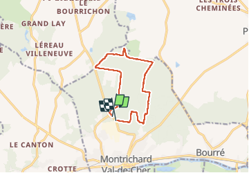

Length
10.3 km

Max alt
141 m

Uphill gradient
94 m
Km-Effort
11.6 km

Min alt
113 m

Downhill gradient
87 m
Boucle
No
Creation date :
2022-06-16 06:46:51.0
Updated on :
2022-06-16 09:02:44.431
2h15
Difficulty : Medium

FREE GPS app for hiking
 SityTrail
IGN / Geographical institutes
SityTrail Plus
The world is yours!
About
Trail Walking of 10.3 km to be discovered at Centre-Loire Valley, Loir-et-Cher, Montrichard Val de Cher. This trail is proposed by Pascal Bernaud.
Positioning
Country:
France
Region :
Centre-Loire Valley
Department/Province :
Loir-et-Cher
Municipality :
Montrichard Val de Cher
Location:
Unknown
Start:(Dec)
Start:(UTM)
362384 ; 5246696 (31T) N.
Comments